The final day promised to be interesting. We would start on the eastern side of the Cumbre Nueva, in the hills behind our hotel, scramble up some heady paths through the oldest volcanic rocks, reach a open green picnic area, and then descend on the other side walking across more recent lava flows, finishing in El Paso, the terrrain on the west and east escarpments being wildly different.
We were following what would originally have been an ancient path linking one side of the island to the other, rather like you find in the passes above Coniston in the Lake District. You could sense the spirits of bygone fellows leading their donkeys carrying their wares on their backs up and down these steep and narrow paths.
The Cumbre Nueva (translates as New Summit) contains the sharp spine of hills that we could see yesterday leading off to the south from Caldera Taburiente to the Cumbre Veija (Old Summit). The harder walk were heading off on the ‘volcano route’ of the Cumbre Vieuja, which sounds like a child’s paradise: lots of craters in a small area to play around in. A part of me wanted to do that walk, but I knew they would set off fast and I want to enjoy the scenery and not be on a forced route march. Cumbre Nueva being slightly smaller than its neighbouring friends with a maximum height of 2100m is rather softer in appearance than the other craggy volcanos surrounding it. and maintains a steady transpiration rate as it is mostly within the cloud forest height range, so it is lush and green. There are many pines on the eastward side whose lines are only broken where the lava has had its strongest grip. On the eastern side the vegetation is more varied and more abundant – tree heathers can grown to 4 metres in height., whereas on the western side they are more stunted in growth due to the lava flows and also to the strong winds which buffet that side of the mountains.

At the bottom of this map is a marker point called Montana de los Tomillos at 1522 metres. That is the point where you change over from east to west. If you enlarge the photo you will see a green path to the right saying Pared Vieja on the east side. We started somewhere along that path, walking continuously uphill for an hour and a half.
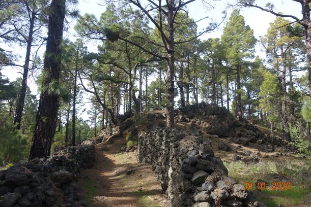
Then we reached El Pilar which is an area that has been cleared to some extent to allow locals and tourists to make the most of the wonderful countryside. You can drive up to this point, there is a small visitor centre, toilets and a snack bar in season. It is very pleasant and cool, although the sun can still creep through the trees. One remarkable thing about this island is its taxi service. Every now and again where a path meets a track you will come across a green sign saying TAXI with several taxi numbers and prices to different places. They are very geared up for walkers and try to discourage vehicles by offering this service, and they are not expensive. The Refugio de La Pilar is a wonderful starting point for a walk. You can do at least six different walks from this starting point and I would have loved to have been able to spend time messing around exploring all of them. Maybe that will be for another visit.
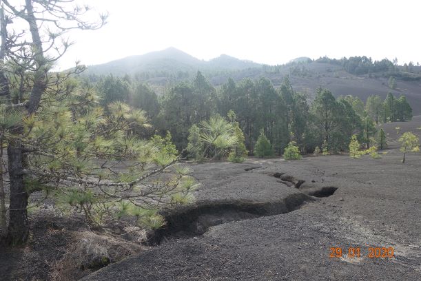
As you leave El Pilar you cannot fail to notice the Volcano Montano Quemada of Tacande, which erupted as recently as 1470-1490, similar to other volcanic eruptions in the south, and indeed the terrain is very similar. You can see the black ash sliding down the hillsides and there are only a few loose boulders here. This ‘sand’ was procured by the locals over the years to make paths and gardens, but that practice has now been forbidden. This tiny loose rock was created when magma was thrust into the air, forming shiny black granules cooling rapidly as it hits the ground. This is called obsidian and it looks like glass. Everywhere we looked you could see it glistening up at us, but try to pick one up and it would mysteriously disappear. I did finally manage to bring a couple of tiny pieces home, along with some volcanic pumice!

This was a very pleasant walk down, with some open areas and lovely shaded areas in the pines. This was the first time there was evidence of water, admittedly not flowing right now, but there were channels in the lava which would allow the water to flow freely when it does rain. The rainy season is meant to be between November and February but as everywhere, the climate is changing and they have had little rain this winter. The annual rainfall is about 327mm p.a, compared with the Isle of Man that has 1139mm p.a, so you can see that if is dries up here they will be in serious trouble.
Throughout this holiday we had come across all kinds of lichen, which of course only grow in healthy terrains. They hung from the trees and where they fell off, it felt quite hard and leathery. The photo below shows such a lichen dripping from a tree, with the backdrop of the Punta de les Roques which is the last part of the volcanic ridge and the first part of the Caldera de Taburiente.

The further down we went we lost the sandy rocks and found ourselves walking over a very craggy lava flow that went all the way down to El Paso. This had been incorporated into the gardens of the local houses

And here we could hear the sound of birds as we went through more pine forests, casting their magical spell on us all as we passed through them.
Nearly at El Paso, we had our final trek over some tricky lava and a few minutes later we were at the Visitor Centre and the bar, where we sat and waited for the harder walkers who were not so far away. The fact that the lava continues right down to the road makes one very much aware that this is a living landscape and that it will always have the final say over mankind.
In this last photo, you can see the whole of our route on the eastern side and reminisce about all the wonderful things we saw.

Distance: 6 miles
Ascent: 948 ft (all in the morning)
Descent: 2041ft
So ends a truly memorable holiday, so inspiring that I have already booked to go walking on one of the other Canary Islands this time next year. For now, I shall resume normal service and report on walks on the Isle of Man, starting this coming Saturday with a report on Peat Monitoring which we plan to do if the weather is suitable.
Thank you for following this blog, and keep in touch.
